This walk starts at The Gwbert Hotel, following the Wales Coast Path south to Cardigan Town across the River Teifi to the village of St. Dogmael’s in Pembrokeshire. It’s a 6 mile walk, ‘point to point’.
We set out on a bright, crisp late February morning joining the coast path directly opposite the hotel, walking along the top of fields which gently slope away towards the coast with splendid views towards North Pembrokeshire.

View south of Cemaes Head, Pembrokeshire.
A small car park provides a great viewpoint across the bay. Apparently this is a good place from which to see bottlenose dolphins and although we didn’t spot any, there was some short lived excitement provided by a family as they parked up with two young children exclaiming they had seen a dolphin. Their parents, using binoculars, scanned the bay intensely but with nothing to see told the kids they were mistaken. They didn’t take this too well and were still adamantly claiming “but it was a dolphin!” as their parents bundled them back into the car to depart!
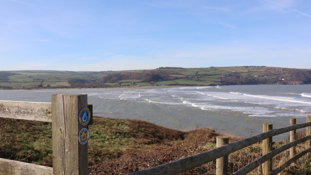
The path continues downhill on a pavement alongside the main road and for a couple of hundred metres there’s no view of the coast or much else. A way-marker post points the way to a narrow track which emerges at an area of dune grass with a picturesque coastal scene.
 We followed the coast path around a holiday caravan park to a shingle bank at the shoreline near a sailing club boat yard, the only sounds on the breeze were a few boats gently bobbing around.
 We walked up a slipway and joined the pavement along the main road, following the course of the estuary as it meanders inland. The path heads away from the highway passing a boat repair yard and onto a countryside trail flanking the River Teifi estuary. It was a really pleasant countryside walk with a chorus of birdsong from the hedgerows as we crossed the numerous farm fields.

The track descends gradually through fields and eventually brings us alongside the bank of the River Teifi and the Quayside in Cardigan.

There was a lighthearted moment here as a swan was strutting confidently along the footway, providing some amusement for a few locals. We wondered if he was walking the Coast path too.
We stopped off for drinks at a quirky, smart cafe, The Fisherman’s Rest. It’s an old wharf building on the riverfront and is a nice, comfortable place to stop off for drinks before we continued on our way.
St. Dogmael’s is a couple of miles further south on the other side of the River Teifi. We passed the recently restored Cardigan Castle to cross the footbridge over the river. A statue of an otter sits proudly overlooking the riverside.
After crossing the footbridge over the river, there’s a choice of two routes into St. Dogmael’s, either continuing along the main road or take an uphill lane leading into countryside. We chose the countryside path.
Our boots got plastered on this section as we hiked across some very muddy farm fields, the ground heavily churned up by cattle. Buzzards soared and circled in the clear sky above as we headed downhill to cross a footbridge in a wooded dell then joined a lane to walk down into the village.
St. Dogmael’s

St, Dogmael’s takes its name from a 6th century Celtic saint, reputedly a cousin of St. David. A wood carved sculpture of the Saint stands next to a millpond and just along the road are the grounds and ruins of the once substantial Abbey which was established here in 1120 A.D.

After a peaceful wander around the abbey grounds we walked to St. Dogmael’s main street and the village green which overlooks a stretch of the River Teifi, where nearby is the site of a very interesting natural feature.
Ancient ‘Answer Stone’
Set in a hollow down on the riverbank sits a massive dolmen type stone. This huge rock is a peculiar shape and is hemmed in by a semi-circular stonewall, so it gives the appearance of a serpent’s head emerging from it’s lair!

This stone is known in more recent times as the ‘Blessing Stone ‘ so called because it was at this spot the Abbey monks would bless the local fishing boats launching on the river. But an original name from earlier Celtic times is the ‘Answer Stone’ or ’Carreg Ateb’ in Welsh. The stone is positioned in an unusual place and since our visit we have learned that archaeologists speculate on why the ancient celts placed it here, perhaps over 4000 years ago, with some suggestions that it may originally have formed a capstone of an ancient burial chamber.

So while there’s a mystery about the stone’s original purpose, there’s some ancient Celtic magic here & the reason it’s known as the Answer Stone will become clear. When you stand at the stone and shout out across the river, your words are echoed back from the opposite bank. It’s an intriguing feature at this exact spot and who knew you could have such fun on a coast walk, as we shout out and our echoes rebound from across the river.
We walked on through the village along Poppit Road, to an open space on the riverside to find the distinctive slate pillar which marks the official start or end point of the 186 mile route of the Pembrokeshire Coast Path National Trail.

Pembrokeshire Coast Path official start or end Point
This is as far as we go on this walk, for a good reason. The next time we’ll be at this spot will be when walking from the opposite direction to complete the entire Pembrokeshire Coast Path, at some future date.

The River Teifi at St. Dogmael’s
It had been a fine day with clear blue skies and warm weather. In fact a very fine day as a new UK record temperature of 20.3 degrees for February was set in Ceredigion. It felt like we had been on an early summer ramble, yet officially it was still winter!
On a late winter hike you’d expect to seek out a pub with a roaring fire and a hot meal.

Not today though, as we enjoyed a refreshing cider outside on the riverside deck of The Ferry Inn, St. Dogmael’s. As the pub sign states, coast walkers muddy boots are welcome!
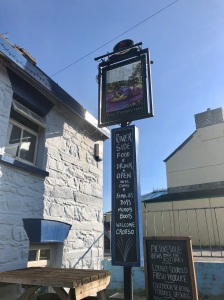
Croeso ~ A warm welcome at The Ferry Inn, St. Dogmael’s
This walk from the Gwbert Hotel to the marker point at St.Dogmael’s was a distance of 6 miles in total.
Map 1. Gwbert Hotel to The Fisherman’s Rest Cafe, Cardigan is 3.8 miles;
Maps 2 and 3: Cardigan to Blessing Stone is 1.8 miles; continuing to the Pembrokeshire Coast Path Pillar is 0.5 miles (0.8 km).


Another detailed and informative description from Rich of a lovely walk to St Dogmaels.
Sunglasses in February ? It just shows that even in winter if you choose the right days you can enjoy a coastal walk.
Cato
LikeLiked by 1 person
Thanks Cato for the kind words and encouragement, it puts a spring in the step for the next walk. Rich
LikeLike