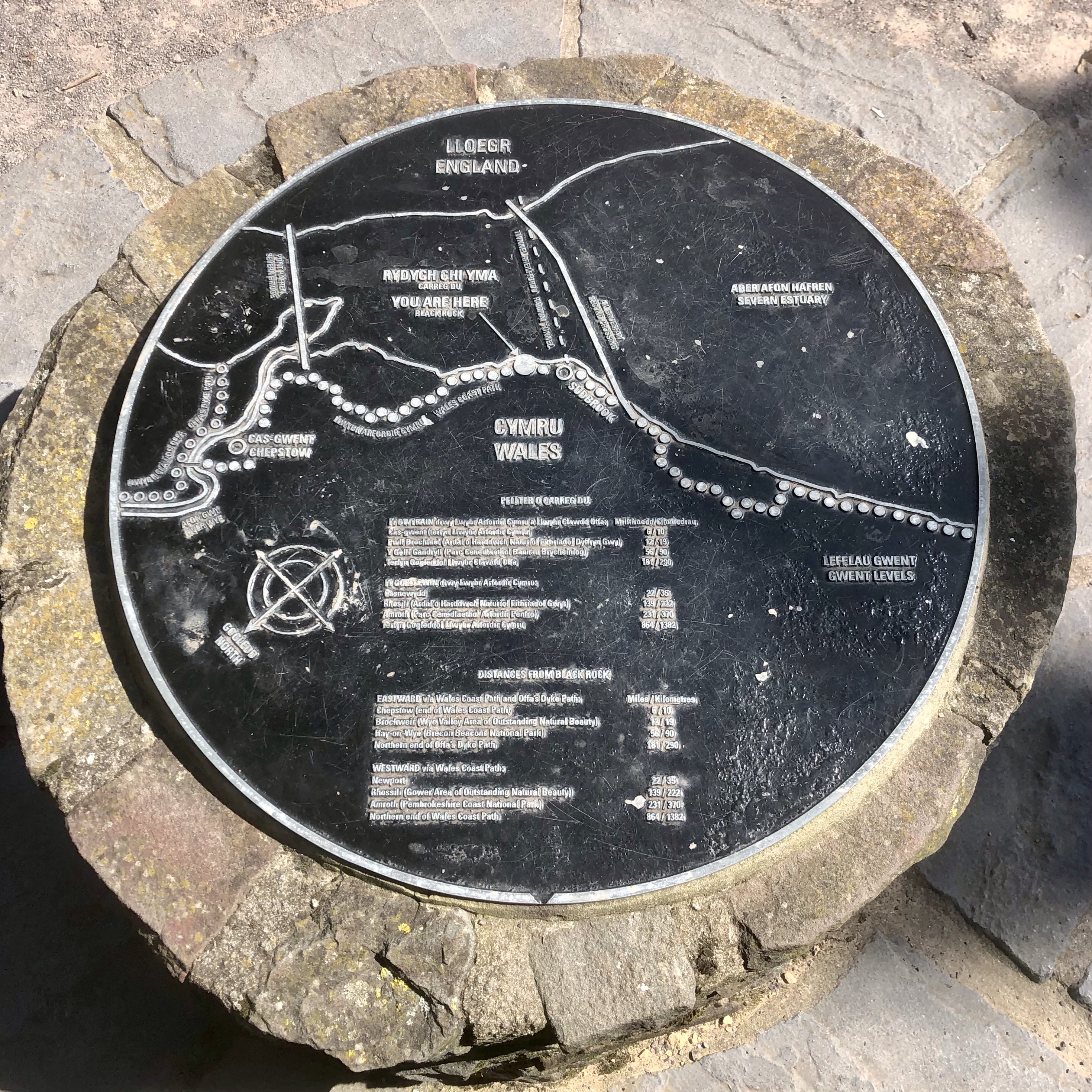
The Wales Coast Path has an official start or finish point, depending on which direction you’re walking the route, in the town of Chepstow, Monmouthshire.
This was our first walk on the South Wales section of the Wales Coast Path and we tackled this one a bit differently.
This walk started at Redwick, on the eastern fringe of Newport and followed the coast path ‘back’ to the official start point at Chepstow.
An advantage of doing the walk ‘west to east’ is to finish at Chepstow town, with plenty of choices for food & drinks and good options for public transport.
Redwick to Prince of Wales Bridge
Redwick is a pretty rural village centred around St. Thomas Church and with a nice traditional pub, The Rose Inn nearby. There are a couple of interesting features at the Church. Just outside the grounds on the village green is an old set of wooden stocks.
On the exterior wall of the Church is a carved mark recording the height of an event known as The Great Flood in January 1607. Records from the time tell of a tidal wave, up to 10 feet high, which swept up the Severn Estuary and submerged the low lying land, sweeping away local villages.
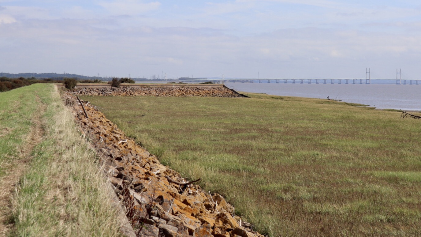
In modern times, a seawall protects the areas of low lying farmland and marshes known as ‘The Gwent Levels’ from the Severn Estuary.
The Wales Coast Path runs atop this seawall for a few miles on this section. An interesting fact is the incredible tidal range of the estuary is the 2nd highest tidal range in the world, only Canada’s Bay of Fundy has a greater range.

From Redwick church we crossed a couple of fields and climbed up onto the seawall, where you immediately get a sense of openness with sweeping views across the wide waters of the Severn Estuary.

With sunshine, a light breeze and the calm waters quietly lapping at the tide, it made for a peaceful and pleasant walk.
The flat landscape ensures a great view ahead of a modern engineering feat, the impressive structure of the Second Severn Crossing, now titled the ‘Prince of Wales Bridge’.
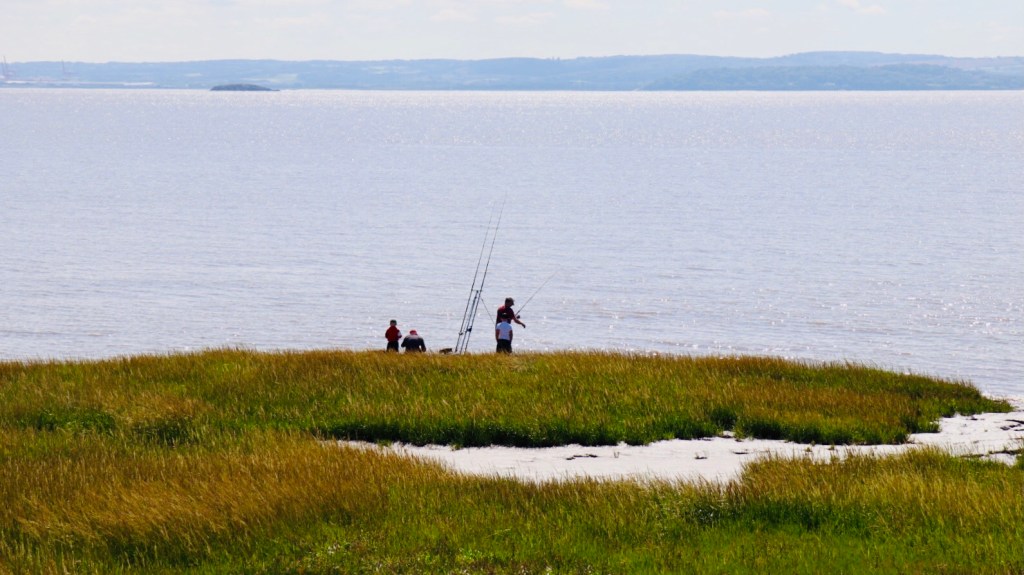
This is an enjoyable section of the walk, very peaceful with just the sounds of the estuary drifting on the breeze, while a group of fishermen could be seen setting up their lines at the edge of the marsh banks.
Unfortunately the flow of the walk is broken near Rogiet due to a military firing range. This means taking a convoluted inland route following minor roads near Caldicot and twice crossing highway bridges over the busy M4 motorway.
Once past the range, it’s good to get back to the banks of the Severn and the bridge looms ever larger as we walk towards, then underneath the huge structure.
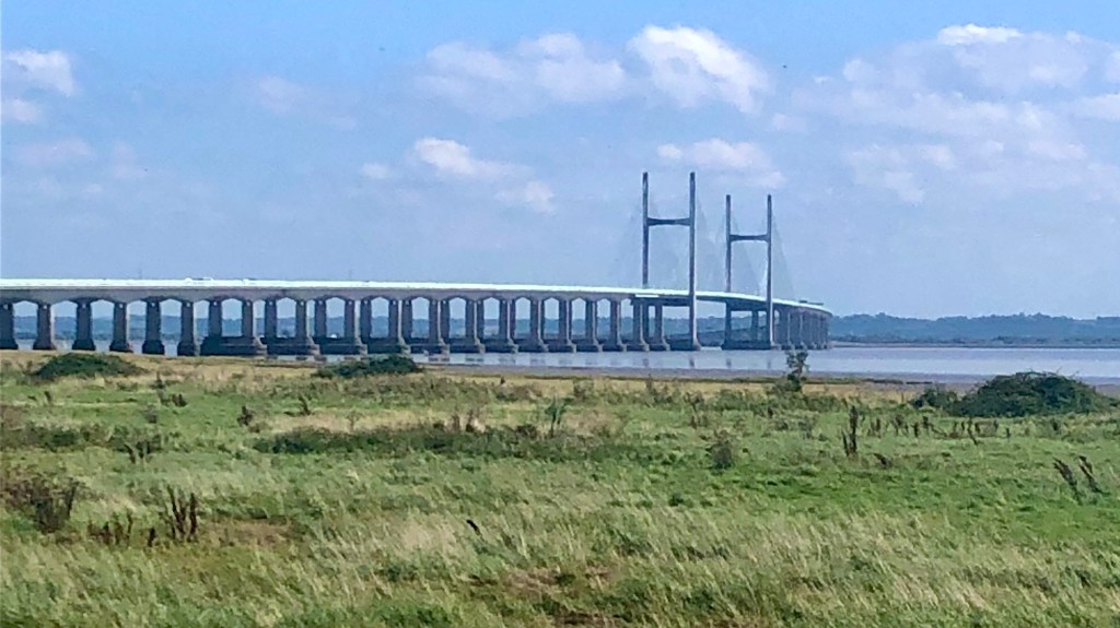
As you pass underneath the bridge you get a great perspective on the scale of the engineering feat and the massive supports which carry the motorway on a graceful curve across the Severn Estuary.

Sudbrook to Mathern
We walked through the village of Sudbrook, a village built in the 19th century to house workers during the construction of the Severn railway tunnel. It was a major engineering feat of the day and the red brick pumping station is still the most prominent building in the village, as millions of gallons of water are drained each day to ensure the trains keep running, even if not always on time.

Sudbrook has a much longer history and the path passes by the site of an Iron Age fort.
Further on are ruins of what remains of a 12th century chapel, now barriered off for safety reasons.
Walking on we reach Black Rock, Portskewett where there’s a pleasant picnic area and viewpoint, so it’s a good place for a rest stop. It seems a popular site for locals as the area was quite busy with lots of families and dog walkers enjoying the fine day outdoors.
A ‘People of the landscape’ art project has installed sculptures along a heritage trail to add some historical interest nearby.
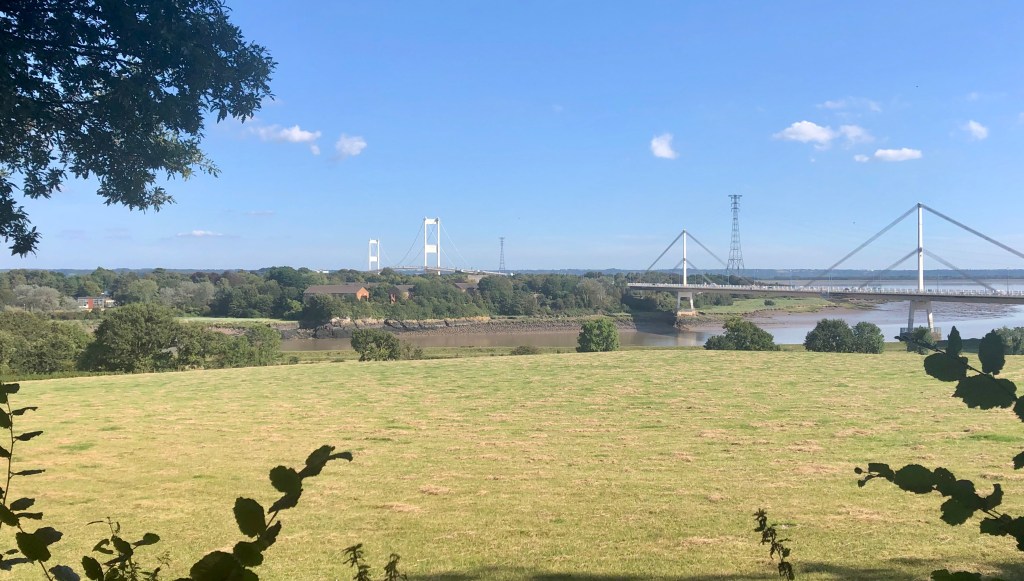
From Black Rock there’s a fine view of the graceful span of the original Severn Bridge, an icon of 1960’s construction.

Further along, the path passes St. Pierre Pill, a secluded inlet which was an historic harbour in post Roman times. From here the path leads inland over a level rail crossing, skirting the edge of a golf course and then across fields towards the old village of Mathern.
Mathern to Chepstow
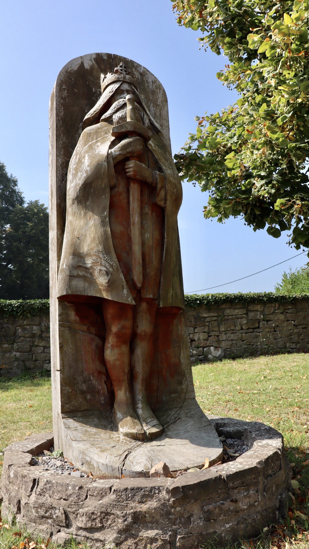
Mathern is steeped in the legends and folklore of a 7th century Celtic chieftan, King Tewdric, who died there after being wounded in a battle at Tintern.
A church was dedicated to him at his burial place and he was declared a Saint and martyr, St. Tewdric.
An impressive carved sculpture of Tewdric stands outside the Church in Mathern.
From Mathern we trudged across some muddy farm fields, then on through some bland urban areas above Chepstow. Every so often there’s the brief highlight of views over the fields to the River Wye and the towers of the original Severn Bridge.
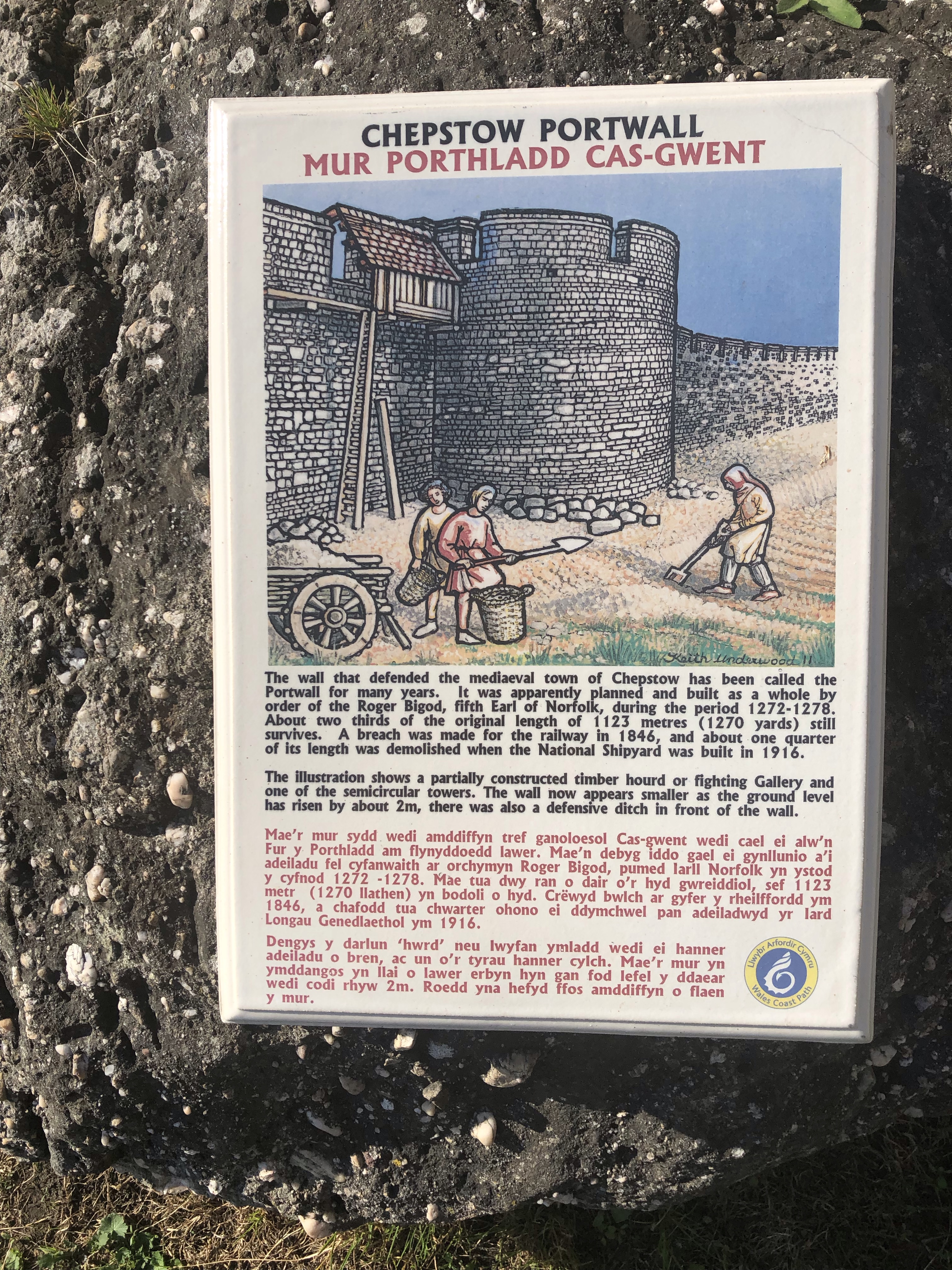
After passing through Bulwark, so named after an Iron Age hill fort on a high position above Chepstow, we began to head downhill into the town. On the hill is a section of preserved Chepstow Port Wall, part of the 13th century medieval town defences. I had some personal interest here, as more than a century ago my late grandfather’s family had lived at Portwall Cottage, but long since gone.

From here it’s a steady walk through the old streets of Chepstow town, the path eventually running alongside a lovely riverside setting overlooking the elegant span of the ironbridge on the River Wye.

Along the riverside path is a landscaped area with a couple of stone pillars which mark the start / finish point of the Wales Coast Path.
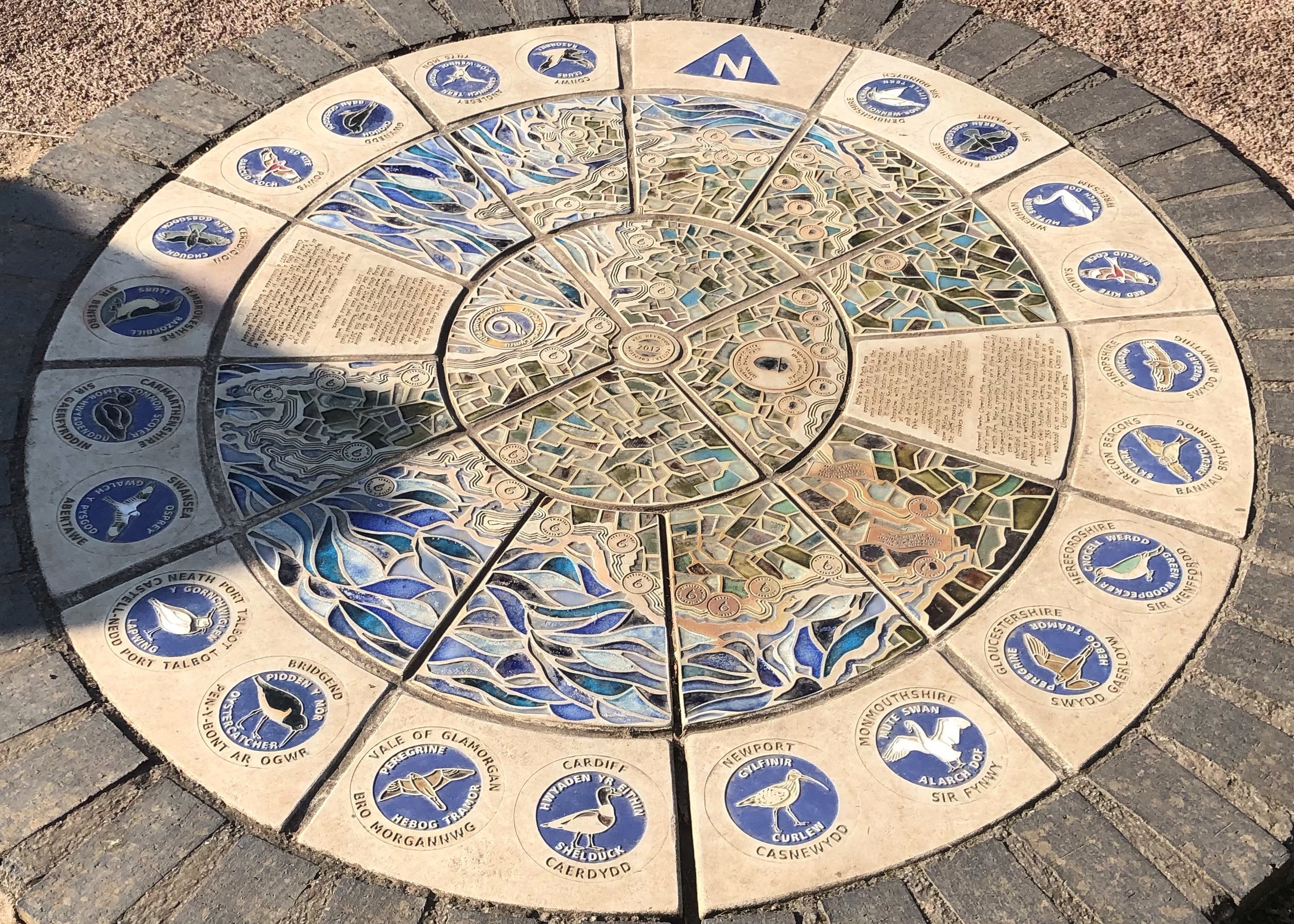
Nearby there’s a colourful mosaic artwork commissioned to commemorate the official opening of the path in 2012. It depicts wildlife and scenes representing all the areas which form the coastline of Wales. It’s a fine piece of public artwork.
This walk ended here, but we took the opportunity to spend the remainder of the day going for a wander to explore the historic town and the magnificent Chepstow Castle at our leisure.
Route Stats
Start ~ Redwick Village / Finish ~ Old Wye Bridge, Chepstow.
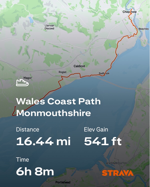
A long but enjoyable walk with scenery, interesting history and iconic bridges along the way. Walking was easy going along the Severn Estuary, on a low and flat landscape.

The road walking on the inland section at Caldicot & the urban approach at Bulwark outside Chepstow were not so enjoyable sections.

For walkers looking to avoid the road sections around the M4, I’d suggest an alternative would be to split this into 2 walks, either side of Caldicot, to focus on the main highlights along the Severn Estuary and Chepstow.

Enjoyable to walk that again through your eyes. Lovely shots of the Prince of Wales Bridge.
LikeLiked by 1 person
Thanks Tony
LikeLike
A good walk to start out on a new path network.
Full of really interesting observed information and quality photos to match.
The Route Recap provides a very useful summary – especially the ongoing mention of places to rest and eat.
A bit of a marathon this one – well done.
LikeLiked by 1 person
Thanks Cato, 👍
LikeLike