This walk takes us from the ancient site of St. Govan’s Chapel, westwards across a rugged and wild coastal landscape to the awesome natural rock feature “The Green Bridge of Wales’. As this area is part of the Ministry Of Defence Castlemartin Range East, access is restricted on military training days therefore planning a walk here in advance is essential.
The start point is the car park at St. Govan’s, which is at the end of a country lane from Bosherston Village. From the car park a path leads across a grass area to the top of a deep sided cove. A set of stone steps lead down into the cove to a genuinely iconic place of Pembrokeshire Coast National Park, St. Govan’s Chapel.
This 13th century chapel was built over a much earlier ‘hermit cell’ believed to be the home and final resting place of the mysterious Celtic Saint Govan, who died here in 586 AD.
There’s a legend that if you count the steps on the way down to the chapel and then recount the steps on the way back up, the numbers never match. We find out later if there’s any truth to this legend.

At the foot of the steps is an archway entrance to the chapel, leading into a sparse small dark room with a single window outlook to the coast. Some visitors say that on entering the chapel, there’s an eerie feeling of leaving the modern world behind and stepping back in time to an age of Celtic myths and legends.
On the left side, there’s an archway recess in a rock crevice. This space is perhaps the most famous of the legends pertaining to St. Govan. This legend tells of his fleeing a raiding party of pirates, when he sought safety by hiding in this crevice and praying for divine help. His prayers were answered as the rocks miraculously closed around him, hiding him until the danger passed, so saving his life. There are markings in the rock which according to the legend are the imprint of Govan’s ribs, cast in the rock as it encased him.

Walking down into the cove provides a dramatic view of the chapel in this unique setting, wedged between the rocks and huge boulders.

Looking out on the wild and windswept rocky cove you can take in a view that Govan himself would have looked upon and imagine for a moment what must have been his peaceful but bleak life spent at this extraordinary place, which still retains an air of ancient celtic mystery.

Leaving the chapel and the ancient world behind us, we climbed the stone steps back to the clifftop. On reaching the top we compared our numbers for the steps and found that yes, we did have a different count on the way down, so there’s some substance to that old legend!
Castlemartin Range
Back on the coast path we passed a military gateway from where a rough stony track heads westwards. Although the official advice is to keep to this track on the range, doing so deprives you of enjoying some spectacular scenic views along this stretch of coastline and would be an uninspiring trek.

Keep to the track – but miss out on incredible scenery
The next 3 miles of coastline is internationally acclaimed for having some of the finest examples of geological rock formations in the UK, so it’s definitely worthwhile going off track to explore where possible and importantly, safe to do so.
Along this coast the landscape is exposed to the full force of the elements so the wind is bracing, ranging from blustery to almost galeforce at times and the sea waves swell and crash thunderously into the rocks below.

This all adds to the experience and the reward for walking nearer to this rugged and wild coastline is numerous spectacular views of towering cliffs, rock arches, hidden caves and incredible scenery at every turn.

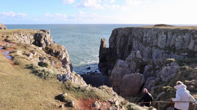
Huntsman’s Leap is a narrow rock chasm with massive sheer sided cliffs. The name originates from the local legend of a huntsman who rode his horse to jump the gap and having successfully done so, he looked back into the chasm and promptly dropped dead from shock. It’s not known how his horse reacted to the feat.

Huntsman’s Leap
There’s a number of places along this coastline that have interesting names. There’s a prominent headland known as The Castle, an intriguingly named Bullslaughter Bay and another is known as The Cauldron.
Near to Bullslaughter Bay there were a few choughs, with distinctive red bills and legs, their Welsh name ‘brân goesgoch’ translates as the red-legged crow. These proceeded to perform some aerial acrobatics and followed us for a time, seemingly showing off for attention with their distinctive call.
Walking near to the clifftops there are extensive views across the incredibly rugged landscape at Bullslaughter Bay.
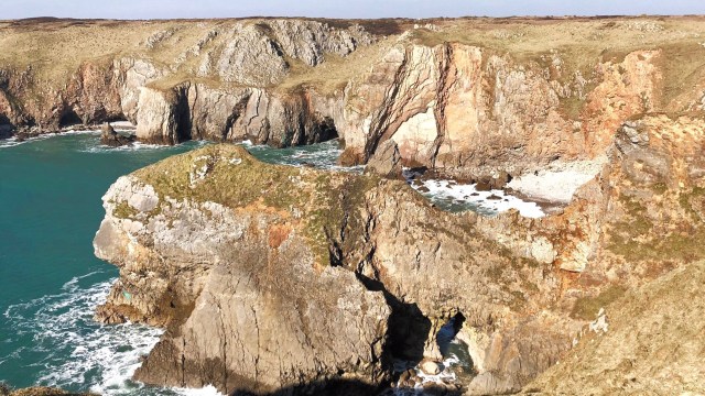
Bullslaughter Bay
Flimston Bay has a secluded beach with rock pillars and massive vertical cliffs which make it incredibly scenic.
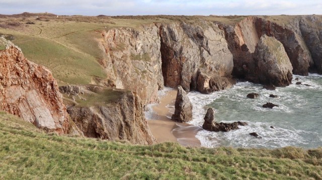
Flimston Bay
Another dramatic headland known as The Cauldron has fearsome, sheer vertical cliffs, which are best viewed from a safe distance!
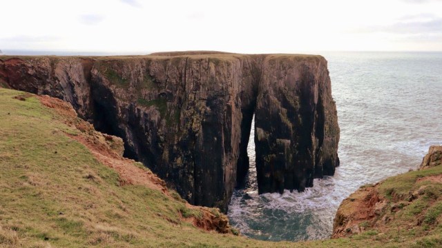
The Cauldron
Further along are a magnificent pair of limestone pillars, known as Stack Rocks, or Elegug Stacks. The word Elegug is the Welsh name for the Guillemot and these stacks are a major nesting site for masses of guillemots, razorbills and kittiwakes during spring & summer, as they cover almost every surface atop the rocks.
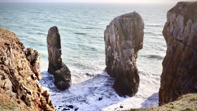
Stack Rocks / Elegug Stacks

From Stack Rocks we head towards one of the most spectacular sights on the Pembrokeshire coast and probably one of the most famous and picturesque landmarks of Wales.
As the path leads to Stack Rocks car park, another path is way-marked towards the coast leading to a raised timber platform, set on the edge of a clifftop. This offers a superb viewpoint overlooking the ‘Green Bridge of Wales’.
The Green Bridge of Wales is a huge and truly impressive limestone rock arch. It’s rightly regarded as one of the natural wonders of Wales and images of the rock feature regularly in magazines and calendars of outstanding Welsh landscape scenery.
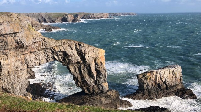
It’s a dramatic coastal scene, with the sound and vision of Atlantic waves which swell and crash into the rocks below. In recent times, Storm Orphelia hit with full force along this coast in 2017 and caused a huge slab of limestone to shear off the seaward edge top of the arch. The appearance and profile of the rock was changed in an instant. The damaged area is a noticeable light copper colour.
The viewpoint is near the boundary of the Castlemartin Range West, a military training area with restricted access only for guided walks by permission of Ministry Of Defence a few times a year. The official coast path route therefore goes inland from here past the closed Flimston Chapel and onto Castlemartin.
Check out our walk at Castlemartin Range West , a National Park ranger guided walk on a rarely accessible section of Pembrokeshire’s coastline.
Route Recap
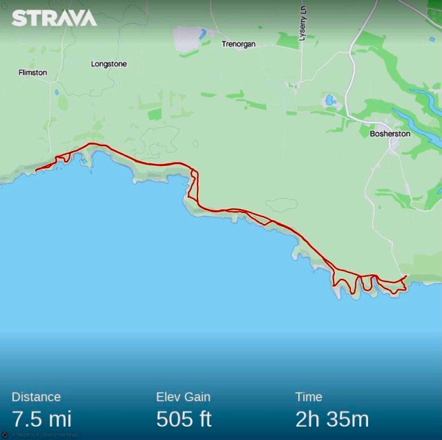
We returned to St.Govan’s by the track across the Range, the return walk distance ‘there and back’ being 7.5 miles in about 3 hours.
This is a thoroughly enjoyable walk, the celtic history of St.Govans, and the unspoilt and rugged landscape with phenomenal natural features along a unique coastline.

One thought on “Pembrokeshire Walk 9 ~ St. Govan’s and The Green Bridge of Wales”