The coastline between the Green Bridge of Wales and Freshwater West lies within the military training area of Castlemartin Range West. As this area has no public access, the official Wales Coast Path route turns inland at Stack Rocks, missing out the coastline by following the highway lanes to Castlemartin village and onto Freshwater West.
However, a few times each year there are limited opportunities to walk the coastline across Castlemartin Range West by signing up to a guided walk led by National Park staff with permission of the Ministry Of Defence.
As we are keen to complete our walks as near to the coast as possible, once this year’s guided walks schedule for Castlemartin Range West was advertised we signed up for Sunday 14 April 2019.
Walks are arranged by the Pembrokeshire Coast National Park Authority and cost £6 per person with limited places available. The walk is about eight miles and is a full day experience of about six hours as the guides provide information talks along the route. There are no facilities on the route, so sound advice is to be prepared and pack snacks and drinks for the duration.
The day started at 09:30 at the main gate entrance to the Castlemartin military base at Merrion where we met Gary, the National Park guide for the walk and the rest of the group. Gary provided the necessary health and safety briefing, explaining that the range is used by the British Army and NATO forces on major military exercises so there’s the possibility of unexploded ordnance. We then received M.O.D. legal disclaimers which sets out in some detail that you enter the area at your own risk and in the unfortunate event of being injured by said ordnance on this walk, you have no claim against H.M. Government.
It’s a case of ‘no name no pack drill’ so we duly signed the forms which were then deposited with a M.O.D Officer and our foray, guided walk, could commence across Range West.

We set off near the Green Bridge of Wales, entering via an access gate to the range and walking across to a rugged and rocky inlet known as ‘The Wash’.

The huge slabs of dark rock hold geological treasures and Gary led the group to an area with many examples of fossils formed in the rocks millions of years ago.

We continued across the undulating terrain of Mount Sion Down and paused near here to view a blowhole cave in a cliff top. Gary explained that a few years ago groups would walk to the edge of the blowhole and look down into the cave. We were viewing it now from a cliff opposite, keeping a safe distance for good reason. A survey had revealed a huge cavern extending under the ground around the blowhole, so the risk of further ground collapsing rules out getting any closer.

Heading westwards, coming into view in the distance were some very prominent rocks along the coastline. As we walked nearer the sight of the spectacular Pen-y-Holt Stack rock was surprising with its amazing profile.

To the right of the Stack rock is a noticeable V shaped gap between two cliff faces, which was once a huge rock archway known as Cabin Door but has long since collapsed.
Pen-y-Holt Stack has been battling the elements over millennia and the limestone rock strata now takes on an unique, bizarre even, appearance which amazingly resembles the profile of a mans head when viewed from the nearby clifftop.

Nearby Pen-y-Holt Bay has some spectacular cliff scenery with unusual limestone rock forms, with caverns, incline dips and sweeping folds.

Walking around to the far side of Pen-y-Holt Bay provides a different perspective of the Stack rock as it seems to be tilting precariously against the constant weathering and waves. Adding to the interest is that the profile has a markedly different appearance from this angle. It’s not the same bloke!

 The next point of interest is the ancient earthwork defences of an Iron Age coastal promontory fort, which is still evident in the landscape.
We stopped here as Gary gave a talk on the vast scale and layout of the fort settlement and explained that some mystery surrounds the true purpose of these substantial defences found at a number of sites along the coast in South Pembrokeshire.

It’s intriguing to think of this isolated place once being a heavily populated settlement, with planning and effort to develop such a structure by ancient Celts two thousand years ago.
We set off from the fort boundary heading towards the ridge of Linney Head, where a coastal lookout is located at the headland.
On the way between the two locations we took what proved to be a fortuitous short detour, a ‘recce’ to view the nearby Hobbyhorse Bay.

A huge stack rock dominates the bay and because this rock was said to resemble a hobby horse, that’s the reason it was so named in Victorian times.
In the waters a pair of Atlantic grey seals appeared and they caused some excitement as everyone in the group reached for a camera or binoculars. This pair seemed to enjoy the attention as they came closer to shore and they even kept an interested eye on the group, as we walked to the other side of the bay. Their appearance was a fantastic bonus and real highlight of this walk.
Walking towards the headland of Linney Down, Gary told us to be aware of small black Marsh Fritillary caterpillars, an endangered species. Gary explained their early hatching was unusual due to the mild winter, a real concern because their plant food sources were not yet available. The Castlemartin Range is an important major habitat for the Marsh Fritillary butterfly, so hopefully many will survive this year and this will not be a catastrophic event.
Rounding the headland to a small bay named Blucks Pool, an isolated beach and we walked down to the soft sand with lots of shells, over to the rocks at the far side.
We walked on to another isolated but very picturesque beach, Frainslake Sands, backed by extensive dunes. At the far end is the boundary of the Military Range and some extensive rock outcrops separate this bay from the beach at Freshwater West.

The next stage of the walk was inland through the Brownslade burrows and along FrainsLake which was actually once a freshwater stream to the coast but was dammed to create a lake. It was interesting to see the flooded picturesque ruins of Frainslake Mill (photo below) and other long abandoned buildings which had once been part of the extensive Brownslade farm estate.

 At the end of the walk returning to Stack Rocks we see one of the most prominent buildings on the Range, Flimston Chapel. It dates from medieval times and was restored in the Victorian era, it now stands isolated and abandoned, but is a notable landmark feature on the Castlemartin Range.
Our guided walk across Castlemartin Range West had been an interesting day with knowledgeable guides providing details about the geology, nature, landscape and history of the area featured along the route.
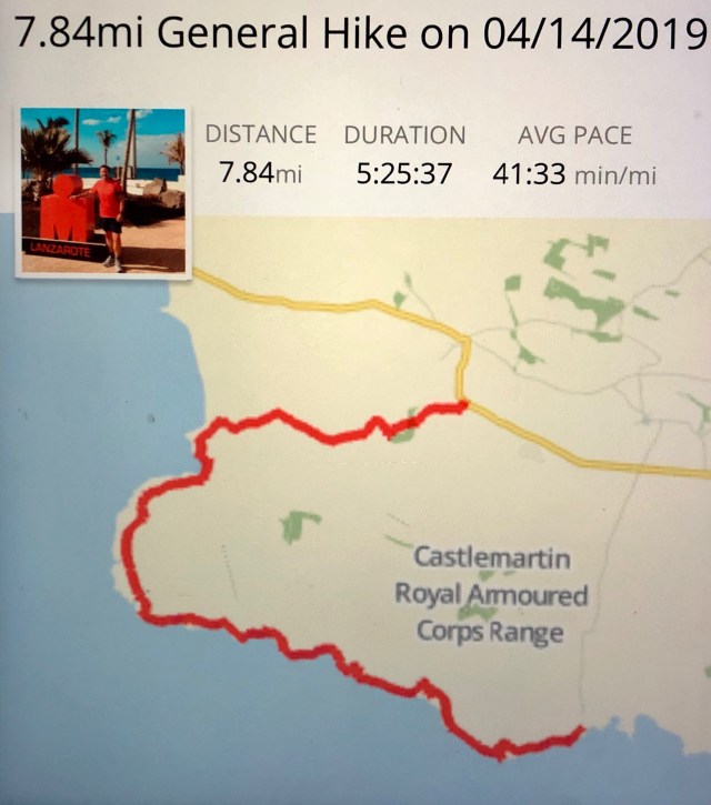
This walk covered 7.84 miles over five and half hours, an enjoyable way to experience a coastline and landscape rarely accessible to the public.

Did this walk a few years ago now. Fabulous walk and well worth the effort to secure a place on it. Here’s my blog entry:
http://www.bucknellshropshire.com/2gs-coastpath/walks/pembrokeshire2/?post_id=251&title=stack-rocks-castlemartin-range-west-to-linney-head-amp;-frains-lake-%5B7frac12;-miles%5D
LikeLike
Hi Graham, agreed it’s a great walk. Just read your blog entry and noted you were able to stand near the blowhole cave at that time, it’s deemed too much of a risk now. All the best.
LikeLike
I can imagine that it would become more and more of a risk Rich. It is a truly wild and beautiful part of the coast – especially the HUGE bridge!!
LikeLiked by 1 person
Great stuff Rich. I think this must be one of your most interesting walks so far. The anecdotes to accompany the brilliant photography make it come alive. Marvellous stuff.
Cato
LikeLiked by 1 person
Interesting to read this as it is a section that I have had to miss on both my PCP walks. I think it’s a shame it’s not open more often.
LikeLiked by 1 person